No reports of deaths or injuries; storm brings welcome rain to fire-plagued Northern California
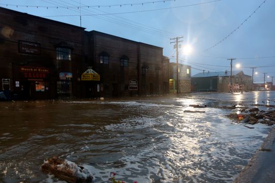
ANCHORAGE, Alaska — Floodwaters were starting to recede in some parts of western Alaska that were battered by the worst storm in a half century, leaving debris flung by the powerful Bering Sea waves on beaches and in seaside communities.
The storm, the remnant of Typhoon Merbok, was weakening Sunday as it moved north from the Bering Strait into the Chukchi Sea off Alaska’s northwest coast. But it remained a hazardous threat to smaller communities along Alaska’s northwest coast, said National Weather Service meteorologist Kaitlyn Lardeo.
“This guy is going to hang out in the Chukchi Sea for the next few days and just rapidly weaken because it’s so stationary,” she said.
The storm’s crashing waves caused widespread flooding and damage along 1,000 miles of the Alaska coastline, Alaska Gov. Mike Dunleavy said.
It was also massive system — big enough to cover the mainland U.S. from Nebraska west to the Pacific Ocean and from Canada to Texas — that has influenced weather systems as far away as California, where a rare late-summer storm was dropping rain on the northern part of the state.
There have been no reports of injuries or deaths in Alaska, the governor said during a Saturday evening news conference. However, roads have been damaged and state officials are assessing potential damage to seawalls, water and sewage systems, airports, and ports.
Several communities reported the force of the incoming water, often propelled by winds gusting near 70 mph, knocked some homes off their foundations. One house in Nome floated down a river until it got caught under a bridge.
Many homes were flooded and about 450 residents on the western coast sought refuge in shelters, with more than half of them at a school in Hooper Bay, where they ate processed moose donated by village residents. Others rode out the storm on higher ground outside their communities.
The former typhoon caused the highest water level at Nome — 11.1 feet above the normal tide level — since a large storm in 1974, and other communities might have surpassed levels seen in 48 years ago.
“One of the big features of this storm was the wide swath of significant damage,” said Rick Thoman, a climate specialist with the International Arctic Research Center at the University of Alaska Fairbanks.
“So, did it live up to the hype? I would say absolutely,” he said of the storm, which had officials urging people to prepare days before it hit.
Becca Luce and her family live about a half mile from the Bering Sea coast in Nome.
“We have a pretty good view of the ocean from our living room,” she said. “We could see the waves crashing form our window and going over the road.”
Nome itself was inundated, including Front Street, the city’s main business thoroughfare that also doubles as the finish line for the Iditarod Trail Sled-Dog Race. The city’s mini-convention center, which also serves as Iditarod headquarters for the end of the race each March, was surrounded by water.
One downtown restaurant, the Bering Sea Bar and Grill, was destroyed by fire Saturday night, but the cause and whether it was related to the storm is not yet known, said interim city manager Bryant Hammond.
The receding water revealed the detritus left in the streets and yards, including trash, organic debris, rocks and asphalt, Hammond said. Cleanup was to start immediately.
Part of a highway was washed out in Nome, forcing residents to use a bypass to reach the community of Council, adding up to 15 miles to the 72-mile trip, he said.
“Another major concern is that freeze-up is near, and all of this damage to the roads will need to be repaired before the month ends,” Luce said, using the local term for the onset of winter, which is in October in many parts of Alaska. “And it’s hard to say if that will be possible, especially for the remote village villages without as many resources as Nome has.”
Dunleavy, who issued a state disaster declaration Saturday and is considering seeking a federal disaster, said state officials intend to get communities up and running again as soon as possible.
“We just have to impress upon our federal friends that it’s not a Florida situation where we’ve got months to work on this,” he said. “We’ve got several weeks.”
The rain in Northern California helped firefighters increase containment on the biggest wildfire in the state so far this year. The Mosquito Fire in the Sierra Nevada foothills northeast of the capital of Sacramento was 34% contained after downpours early Sunday. More rain was expected, which fire spokesman Scott McLean called a mixed blessing.
“It did help a bit to stifle that aggressive fire,” McLean said. “But we’re going to have new safety issues now with all the mud that’s out there. And the ground moisture could cause some of those damaged trees to fall over.”
An average of a quarter-inch of rain fell overnight across Marin, Napa and Sonoma counties north of San Francisco, with more than double that amount recorded in some mountain areas, the National Weather Service said.
Winds gusting up to 40 mph were forecast Sunday along Northern California coastal areas and at higher elevations in the Sierra Nevada. Gusts that strong can blow down branches and drought-stressed trees and cause power outages, warned weather service meteorologist Ryan Walbrun. He said thunderstorms were expected on and off until at least Monday, making for slick roads during the morning commute.

